"a caterpillar doesn't just grow into a butterfly. a caterpillar must undergo metamorphosis, and a cocoon is where a caterpillar risks it all: enters total chaos, undergoes total rebuilding, and is born to a new way of living. only in taking the risk of entering that inert cocoon can the caterpillar go from dormancy to potency, from ugliness to beauty."

Showing posts with label daytrip. Show all posts

Friday, September 20, 2013

mission accomplished in iligan city: six waterfalls in one day!


oh yes! it can be done. actually, the target was to go to 7 waterfalls and, if not for circumstances beyond our control, we could have been to 8.


mission impossible and ultimate daytrip experience:
six waterfalls in an eight-hour adventure
 in iligan city


the 8-hour adventure of pinas flashpackers in iligan: 
waterfalls, waterfalls, and more waterfalls
08.23.13 six key stops, multiple public transportation transfers, and LOTS of walking | 
iligan -- "the city of majestic waterfalls"


in sitio kalubihon, brgy. dalipuga: [1] pampam falls. [2] unknown photogenic cascade downstream of pampam falls. [3] another unknown falls further downstream of pampam with deeper and more photogenic all-natural pool (accessible from the top of the falls or sa bakilid; just choose your own thrill).


via sitio dodiongan, brgy. digkilaan: [4] dodiongan falls 


via brgy. buru-un and brgy. ditucalan: [5] tinago falls


in brgy. buru-un: [6] mimbalot falls


missed (not our fault): maria cristina falls due to temporary closure of NPC nature's park/MinGen facilities to the public (a security-related proactive measure), missed (time & energy constraints and confusion over the location): kalubihon falls>

before this, the last time i set out to see some of iligan's more than twenty waterfalls was in december 2009.

kalubihon falls | february 2000

13 years ago, this was kalubihon falls -- we climbed above the cave instead of going inside it to eventually get to the foot of the falls. once we made our way down to the foot, we explored the cave. we went back upways and explored the upstream, too.

[watch out for the complete story; this post will be updated in the coming days.]


related posts:
In Focus: Iligan City, Her Lures, and More
destination: tinago falls


Monday, October 01, 2012

strolling in balisong country


"i'm walking on sunshine..."
-- walking on sunshine, lyrics


15th of november 2009
taal: the balisong and barong tagalog capital of the philippines
enjoying a sunday afternoon in this old town of good repute with claire and marissa

in southwestern luzon lies the heritage town of taal, one of the 31 municipalities of the first class province of batangas. it is a charming 4th class municipality located along the pansipit river, the main outlet of the famous taal lake to balayan bay.


the welcome marker to the heritage town of taal

taal is an ideal walking tour destination. within its territory are well-maintained ancestral houses and heritage structures -- a number of them are national historical landmarks -- which date back to the spanish colonial period. taal --  the idyllic town itself -- is a national historical landmark. it is also the balisong (butterfly fan knife) and barong tagalog capital of the philippines.


where is heritage town of taal in the province of batangas?
location of the municipality of taal with respect to the municipality of sto. tomas, batangas
image source: google maps
(i provided the red and light green labels)

it was one late morning on a sunday when claire, marissa, and i pursued a roadtrip to the town of taal from sto. tomas, batangas.


how we got there
bus ride from sto. tomas to lipa, jeepney ride from lipa to taal

we were supposed to ride a lemery-bound bus from the public market of sto. tomas but the buses that came our way were few and full. we opted instead to take a bus going to lipa and got down at the lipa bus stop in front of the local big ben. from there, we rode a public jeepney bound for lemery, batangas. we made sure not to go beyond our sunday afternoon destination by informing the driver that we're only going to the town of taal and not all the way to lemery.


destination: the heritage town of taal
walking around the national historical landmark


we knew we were in taal because we saw this! ,'-) | taal park 

when we arrived in taal, the streets were deserted. manny pacquiao's firepower fight with miguel cotto was still being aired on TV that time and, as expected with every pacquiao fight, most of the people were off the streets and busy paying attention to the bout. just as well for us girls who only wanted to hear about pacquiao's victory -- we were able to walk and look around taal's public market without being persistently approached to buy this or that and/or be asked if we wanted this or that.

our first stop, after taking a look at the public market and after having our sumptuous lunch of adobong dilawsinigang na maliputo at a local restaurant, was the taal basilica.


st. martin de tours basilica (basilica de san martin de tours)
a national historical landmark and the biggest catholic church structure in the far east


basilica de san martin de tours
"the church measures 88.6-m long, 48-m wide and 95-m high
with a 44.5-m high cupola."

dominating the town center of taal is the basilica de san martin de tours, a massive church built atop a hill overlooking taal lake and balayan bay. the existing adobe-and-coral structure was constructed in 1858 as commissioned by fr. marcos anton and designed by don luciano oliver but its history of being built, relocated, and rebuilt goes back far to the last quarter of the 16th century.

the church's interesting history is complete with volcanic eruption and destructive earthquake backdrop stories!


the basilica from different angles 
taal folk tip: go five steps down the stairs and you'll get a full view of the basilica in your frame

the basilica de san martin de tours, which is also often referred to as the taal basilica, is not just noteworthy in terms of size but also in terms of style. the southwest facing facade of this magnificent church is baroque in style but its main altar is doric. plus, its tabernacle is said to be one of its kind in the philippines as it is made of silver.


the main altar of the st. martin de tours basilica

left to right: the nave of the basilica and the right wing

the chandeliers, the pews, the floor, and the pulpit of the basilica

the right side entrance of the basilica

stairs that lead up to somewhere at the right side of the basilica
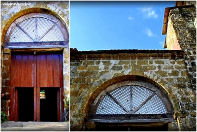

escuela pia
a national historical landmark and the taal cultural center

the present-day structure of the escuela pia, now the taal cultural center, was built by fr. aniceto aparicio in 1885. it is part of the taal park and stands close to the taal basilica.


perspective | part of the escuela pia in taal park and part of the taal basilica

according to the historical marker, the escuela pia is considered as one of the oldest educational institutions of the country. it was established as a church-supervised school and was named after the order of the piarists, the congregation established by jose de calazanz in the 17th century. the augustinians established it in 1839 and their convent served as a school for the underprivileged youth of taal. the escuela pia was also the central school during the american period.

the escuela pia | taal, batangas

walking around taal
more sights to see

within the immediate vicinity of the taal basilica in the town center are the rizal college, OLCA (our lady of caysasay academy), and the municipal hall of taal -- the casa real.


the rizal college of caysasay


gregorio agoncillo mansion
the white mansion in the poblacion

along taal's calle j.p. rizal is an attention-grabbing white mansion with manicured lawn. this is the house of don gregorio r. agoncillo, which is also known as the gregorio agoncillo museum, a national historical landmark.

the gregorio agoncillo mansion
the house where felipe agoncillo, the first philippine diplomat, was born

displayed in its front garden is a statue of felipe agoncillo, don gregorio's uncle and the first philippine diplomat (as he was appointed by general emilio aguinaldo to represent the philippine republic to the united states and to the treaty of paris in 1898). felipe agoncillo was born in this house -- this is probably the reason why the site is also sometimes referred to as the felipe agoncillo mansion. the house has a choice collection of period items and edwardian and spanish-inspired antique local furniture -- from the 1800s and early 1900s.

if the name felipe agoncillo does not ring a bell, perhaps the name marcela mariño agoncillo does. she was the woman responsible for making the philippine flag and felipe agoncillo was her husband. both of them were from taal, batangas.


the ylagan-de la rosa house
a heritage house along calle j.p. rizal

standing close to the white agoncillo mansion is the ylagan-de la rosa ancestral house, which is recognized by the national historical institute as a heritage house.


old world meets new world | the ylagan-de la rosa heritage house

walking on the streets of the heritage town of taal is like being transported back in time. if the ilocos region has vigan, southern luzon has taal.


some of the other old houses we saw in taal

calle for street and clinica for clinic | taal, batangas

yes, i think of taal as southern luzon's vigan and vigan as the ilocos region's taal. ,'-)


balisong
because "knife cuts like a knife..." :)

on our way back to sto. tomas, we made sure to stop by first in taal's brgy. balisong. why? because taal, batangas is THE balisong country!

taal is known for its national historical landmarks and well-preserved ancestral houses. it is also known for the piña cloth, the barong tagalog, fine needlework and high-quality embroidery by hand (burdang taal). it is also very known for the balisong (butterfly fan knife), which is also known as the batangas knife.


glistening batangas blades |  choose your balisong

top of the line stainless steel blades |  mga balisong sa brgy. balisong

it is in brgy. balisong that these pocket utility knives are traditionally well-crafted in various sizes and handle designs. when we went there, i finally saw for myself a real deal viente y nueve traditional balisong -- a 29-cm long butterfly fan knife.

see the comb? i soooo wanted the balisong comb (a comb is concealed between the handles instead of a glistening blade). i did not buy it because i really couldn't justify to myself a php600-worth stainless steel comb when a 5-peso plastic comb would do for my long hair. still, it's a neat piece of handiwork and very nice to have.

but... i did buy my own batangas knives from brgy. balisong that sunday afternoon. (--,) actually, i bought three -- 2 functional ones (1 with old wood detail & another one with horse bones) and a mini balisong keychain.


marissa, claire, and i | sunday afternoon bliss in taal, batangas

i like it there in heritage town of taal so going back there should be in order soon. for one, i want to see the ruins of st. martin de tours church in brgy. san nicolas. i also want to visit the other sites that are listed here and shown on this map which we missed during our afternoon tour -- the marcela agoncillo house, the leon apacible museum, the villavicencio houses, the san lorenzo arch & steps, among others. plus, i want to taste again sinigang na maliputo and adobong dilaw and to experience the rest of taal's food treats. if possible, i'd also like to take a look at the silent "king of bells" housed in the restored dome of the taal basilica.


Wednesday, September 19, 2012

the muddy trek to buruwisan and lanzones falls


"In every walk with nature, one receives far more than he seeks."
-- John Muir


28th of january 2012
a walk to remember in siniloan, laguna

what was supposed to be a usual "walk in the park" to see buruwisan falls at the southwest border of the sierra madre turned out to be quite an ordeal of a trek up and down through mud complete with drizzles and a head-on adventure against armies of what-i-refer to as the limatik liberation front.

when you're just looking at the pics, the adventure may not look like we had difficulties but trust me when i say that this was far from being a mere walk in the park. this one cost me a visit to the hospital, no joke. ;-)

it was the last saturday of january and i reckoned it was a good day to be out. our group of six -- kat, tony, onad, bren, mati, and i -- started our outdoor adventure early that day. we left metro manila at around 6 o'clock in the morning and got to the jump-off three hours after in brgy. macatad of siniloan, laguna by following the commuting directions we learned from online sources.


the sights we saw during our tricycle ride from the siniloan public market to brgy. macatad 

we got off the tricycle at the intersection where we saw a "buruwisan falls" welcome banner on top of a waiting shed. one of the locals, kuya rey, approached us and offered to be our guide. since we were all first-timers in the area and we are supporters of local tourism, we agreed for him to help us find our way to the falls and back.


jump-off, this way |  the signage at the small intersection. 

from the intersection, we hiked a short distance along that road indicated by the "this way" arrow to get to a canteen. although we were eager to already start our trek to the falls, we first had to buy food for our lunch. five of us -- tony, onad, bren, mati, and i -- ordered beef pares rice meals while kat ordered a pork pares rice meal. our "take out" lunch cost each one of us 50 pesos only.

then, off we went to the falls. our trek started with a leisurely hike on a paved road, to the side of which was a strategically placed "discover siniloan" banner featuring two other falls in the area -- lanzones falls and batya-batya falls.


a "discover siniloan" banner for lanzones falls and batya-batya falls

our guide, kuya rey, taking the lead

after a short walk, we arrived at the building where we needed to register-and-pay 50 pesos each before we could proceed any further.


the registration hall for trekkers to the falls
brgy. macatad, siniloan, laguna

the location of the registration building is next to a stream which hikers need to cross in order to get closer to where the multiple falls are nestled in upland siniloan, a trekking destination known as mt. romelo. before we crossed the stream, we took a sidetrip to kuya rodel's place just to pay him a courtesy visit. kuya rodel is that guy mentioned in pinoy mountaineer's feature article on mt. romelo. his property stands very close to the registration building and is difficult to miss.


the facade of kuya rodel's property (a farm) in siniloan, laguna
this photo was taken while mati and onad were buying their supply of korniks

after we crossed the stream, we realized what we had gotten ourselves into -- not a mere walk in the park to see waterfalls but an arduous day climb through mud, mud, and mud. with the the rains from the previous days and the day's drizzles, the uphill path was very uneven, muddy, and slippery.


a walk in the park? not quite ;-)
what i saw when i looked back after thirty minutes of trekking

during a trek, i'd normally be able to take out my DSLR camera at some intervals and take some snapshots but not that time. i didn't bother. i was preoccupied with saving my energy and i was busy maintaining good footing on the muddy ground we were walking on. i only managed to take pictures using my camphone.

after an hour and a half of walking on muddy terrain, we reached a stopover-slash-house where we gladly took a rest and bought fresh buko (young coconut). we also took this chance to free our footwear of unforgiving mud.


"are we there yet?" | after 1.5 hours of "walk in the park, muddy trek edition"
if you make a stop here, you can buy fresh buko (P15 each) and softdrinks (P20 each) 

after almost two hours since we crossed the stream, we finally reached a point where we could see the hills and mounds of the sierra madre where the falls are hidden. while it was comforting to know that we were closer, we were also made aware that we were still a long way away from what we were after -- the sight of the waterfalls! we were already feeling very tired of the mud that clung to us at our every step and we were not yet even halfway. hahaha!


a photo of where we were going taken from where we were
about one-third of the way from buruwisan falls
kuya rey pointed this out --- over that hill, that's where the final path (to the falls) is!

when the mud that stuck to the soles of our footwear became all too much -- causing us to either lose balance and skid and delaying us further, most of us finally opted to walk barefoot through the muddier portions.


walking barefoot, dealing with mud | destination: buruwisan
my trek buddies: tony as boy dungis, kat as inday dungis,
bren as boy pawis, onad as boy limatik, mati as boy putik

however, mud wasn't the only problem. we started seeing limatik (blood leeches) "shooting" off the mud -- there's a lot of them along the path!!!  there's a thriving community of them bloodsuckers and we weren't even prepared for them.

we thought we could get respite from the sight of the limatik armies by avoiding the mud and taking the greener paths but we were wrong. there's even more of them waiting in the greens for their unsuspecting warm-blooded victims and they successfully did get to us. a surprise attack by the limatik liberation front, it was. ugh!

they -- the limatik -- are nasty little creatures with outstanding acrobatic skills so do not undermine their ability to get to your skin. there was a moment when i really looked at them and they seemed to perform a wave in unison, as if giving a salute to their onlooker. flirty parasites!


walking in the rain | beautiful scenery with all the greens
this trail is best avoided as this is limatik haven -- super plenty  of bloodsuckers here!
don't be deceived by the beautiful scenery ;-)

we finally reached the campsite three hours after we left the registration hall. since we were only there for the day hike and not to stay overnight, we immediately proceeded to buruwisan falls -- an exhausting walk away (at least, for the starving) and a steep way down from the campsite. we were hungry and ready for lunch but we all agreed that we would go down to see the falls first before we could feed ourselves.

so walk further, we did. then, we exerted our muscles some more by going down a wall of rock-and-roots to finally behold buruwisan falls with our own eyes.


my mud-soaked feet, the trail down to buruwisan falls,
and the roots that one has to hold on to

this steep trail is a "shortcut"to buruwisan falls
it's a wall of rock and roots

when we finally got to the foot of the wall safely, we looked around and allowed our eyes to feast on what we went there for to see -- buruwisan falls! after taking some pictures, we took our rest and had our lunch while sitting/standing on the rocks scattered on the natural poolside of the falls.


the 180-ft high buruwisan falls | siniloan, laguna

tempted by the sight of clear, flowing water, i decided to remove my trekking pants (i wore shorts underneath, hehe) so i could properly clean off the mud. i soon started shrieking when i saw blood running down my legs -- multiple bloody limatik suck-bites!!! ewwww, yuck! i thought members of the limatik army only got as far as my exposed feet but noooooo. they got as far as close to my knees. ulk.

worse for me, clotting didn't happen right away even after the limatik left my skin -- by the time i removed my pants and saw blood, there was no limatik in sight but the bloody wounds were clearly limatik suck-bites and each one of them was still bleeding!

i later learned that those nasty limatik release anticoagulant when they attach themselves to their victims -- hence the continuous bleeding, delayed clotting.


the bleeding limatik suck-bites on my legs
only 3 are visible in this photo but there were 2 more at the back of my right leg

since we were already in the area and lanzones falls was just a short trek away, we set aside thoughts of how tired we were from our muddy trek. we walked further, crossed the river, walked past a meter long dead snake, and walked some more through water & on rocks to get to lanzones falls. 


the 70-ft high lanzones falls | siniloan laguna

we asked kuya rey how the falls got the name lanzones and he said it was because the shape of the cascade is similar to the shape of the leaf of the lanzones. (note to self: we have a lanzones tree in iligan, i should check the shape of the leaves of that tree to verify this information.) the other explanation is that (and this is according to the mt. romelo feature article in pinoy mountaineer) lanzones trees are plenty in the area. buruwisan falls, on the other hand, got its name from the type of hardwood that grew along the banks of the romelo river.


our guide, kuya rey | a very colorful caterpillar we found in front of lanzones falls
and a portion of the wall of jagged rocks facing lanzones falls

if the muddy trek to buruwisan and lanzones falls gave us a difficult time, the muddy trek going back to the jump-off proved to be even more difficult. the muddy, slippery, and uneven downward sloping path was not giving us traction and we were constantly sliding, skidding -- it was like mud-boarding minus the board. after kat and tony fell on their butts a number of times, they finally decided to stop walking on their own and took a chance at guided horseback riding. 

i was determined to walk all the way back and refused to be tempted by the horses. i was trying to enjoy that energy-demanding muddy trek, despite the slides and the near skids, the strain on my lower limbs, and the threat of getting more suck-bites from those i-really-wanna-squish-them-dead limatik. however, so much for my 'best laid plans'. pft. things took a turn from bad to worse for me when i slipped and, in the process of saving my balance, the sole of my bare left foot accidentally hit a sharp edge of a rock jutting out from the muddy trail.

i felt an intense pain and was forced to position myself close to the ground, just to manage the unwanted sensation. i thought pain was all there was to it until onad pointed out the blood that began to mix with the mud -- oh nooooooooo! my left foot got injured at a most inopportune time!!!

i asked onad to examine the sole of my left foot for me and he couldn't tell me right away the real deal about it because he didn't want me to faint. haha. he merely confirmed that i was wounded so i asked him if it could cause my big toe to be cut off and he said no. that relieved me a bit but the sight of so much blood mixing with the mud definitely did not give me relief. (i later found out that, when onad first examined my wound, he saw a lot of blood gushing out of the wound. "bumubulwak-bulwak" was the word he used to describe it.)

with mud all around us and knowing we were still a good 1.5-hour walk away from the jump-off, we merely applied pressure to the wound to control the bleeding and cleaned it with my drinking water. i put a pad of clean wet tissues and tied a strip of plastic cellophane around the wounded portion of my left foot to keep the make-shift cushion in place. talk about third world emergency remedy, bow. i wore my strapped sandals and, then, i started walking again. by this time, my legs were already sore and shaking from having to keep my balance and avoiding skids and the sole of my left foot was throbbing with pain. it was a very, very uncomfortable walk -- that squishy feeling (as mud seeped in and bathed my wound in almost every step i took) was creating bad images in my mind.

it was close to sundown and no horses came our way anymore. i had no choice but to continue walking through mud (and horse manure, no doubt) with my injured foot.

kat and tony -- thanks to the horses -- were the first ones from our group to return to the registration building. onad and bren followed. mati and kuya rey kept me company. i walked on despite the mud and pain because i knew that my injury was dictating the pace of our group. it was already dark, around 6:00 (or was it 6:30?) in the evening when we finally got back. only then did i have the chance to clean myself and my painful wound with mud-free running water. it's a good thing they have comfort-slash-changing rooms at the back portion/riverside of the registration building.

since bren brought a decent first aid kit, we were able to clean my wound with real antiseptic (betadine) and put terramycin. with we, i mean to say that bren did the cleaning, i did the wincing, and the others looked on and shared their thoughts on how the wound should be dealt with. hehe. for good measure, we covered the wound with elastic bandage -- we were still in siniloan, laguna and quite a long way from home -- there was no way i could get rid of the fresh wound just like that and my injured sole needed a cushion because there was more walking to do.

the next day, 29th of january 2012, i  brought myself to the hospital and sought proper medical attention. i then wrote: yesterday's adventure with kat, tony, onad, bren, and mati was... too much for one day! :) my "badges" of courage include: 11 limatik marks, 1 incision on my right big toe, and 1 painful lacerated wound on my sole just under my left big toe with some neighboring abrasions and a bruise. go figure! today, i was given 3 injections: 1 short-acting anti-tetanus shot, 1 for skin test, and 1 long-term anti-tetanus. plus, i was given prescription for cloxacillin, mefenamic acid, and mupirocin and the option not to report to work for 1-2 days. go figure, again!

two weeks later, i still had walking difficulties because the lacerated wound on my sole happened to be a major pressure point -- with constant walking (since i did not stop myself from doing my usual daily activities), it took a long time to heal.

don't get me wrong. despite the trau-matik (trauma + limatik + putik) experience, we still had much fun! :D


p.s. lesson learned from this adventure? do not keep native guavas in the pocket of your trekking pants. hehe.


Tuesday, September 11, 2012

getting to know the angono petroglyphs in binangonan


"History is a symphony of echoes heard and unheard.
It is a poem with events as verses."
--Charles Angoff


9th of june 2012
history, culture, and art appreciation day on a june 2012 saturday
a day for seeing the angono-binangonan petroglyphs (in binangonan, rizal) and visiting balaw balaw specialty restaurant and art gallery (in angono, rizal) among other things (like an afternoon drive and a nighttime drive through very slow moving traffic)


the angono-binangonan petroglyphs: the earliest pre-historic rock art in the philippines

many, many, many, many years ago (read: around 3000-2000 B.C.), somewhere in the elevated portion of what-eventually-got-referred-to (at some point, at least) as the common boundary of angono, binangonan, and antipolo of rizal province, human and animal-like figures were engraved on a wall of massive rock.  defined by an overhang and a shallow cave-like opening, the rock had volcanic origins and its surface was soft enough, chipping upon contact with tougher materials, but the wall as a whole remained resistant enough to preserve carved patterns with the passing of the ages.


the angono-binangonan petroglyphs: pre-historic rock art

for a long, long time, the existence of pre-historic rock engravings in rizal province, the cradle of philippine art, were not part of the public's attention. this changed in 1965 when carlos "botong" v. francisco, the renowned muralist from angono, rizal, reported to the national museum what he and a group of boy scouts discovered during a field trip  --  "a cave with drawings of a primitive quality."

the cave turned out to be a rock shelter and the drawings became known as the angono petroglyphs, with petroglyphs being the apt term for the 127 pre-historic carvings scattered on the 63-meter wide wall of ancient rock. in 1973, the site was declared as one of the philippines' national cultural treasures by virtue of presidential decree no. 260.


site of a natural cultural treasure | part of the 63-meter wide wall of the rock shelter

how to get there

according to the national museum's archeological sites and branch museums division (ASBMD) page for  the angono petroglyphs, "There are three two-hour routes from Manila to Rizal province. The northern route runs from Caloocan City to Marikina City. The middle route runs from EDSA to Pasig. The southern road passes through the town of Parañaque." 

for commuters, the blogspot of binangonan tourist attractions has this: "Take a metro bus, taxi or jeepney to EDSA/Crossing or the Farmer’s Market in Cubao, Quezon City and proceed to the jeepney or FX terminal within the shopping area. These vehicles are bound separately for Antipolo, Taytay, Cainta, Binangonan, Angono, and Tanay." once in binangonan, hire a trike... but... but... the roads going to the site of the petroglyphs are steep! check first with the driver if his trike can make it -- some can, most can't.

to get to the angono petroglyphs, our trio -- kat, bren, and i -- followed the directions shared by supernormalgirl. very, very useful! :)


the landmarks we saw along the way which assured us that we were on the right track
(1) angono, art capital of the philippines and home of the higantes festival
(2) the angono marker in brgy. san isidro (3) just after the guard station along east ridge avenue
(4) the pretty tunnel leading to thunderbird resorts and casino, and
(5) the motorpool garage of the eastridge golf club

coming from the welcome tunnel of thunderbird and eastridge along east ridge avenue and col. guido road, there is an "angono-binangonan petroglyphs" marker on the left side. 


the marker along east ridge avenue-slash-col. guido road

just follow the direction of the yellow arrow leading to a dirt track. the motorpool garage of eastridge golf club is just nearby and the site of the petroglyphs is just a short walk away -- through a tunnel, around a bend, and along a straight path to the building of the binangonan branch of the national museum.


the oldest known work of art in the philippines and a national cultural treasure

the name "angono petroglyphs" is somewhat a misnomer. the rock shelter is located three and a half kilometers southeast of angono and it is already part of the municipality of binangonan of rizal province. since the name of the site already stuck and striking out "angono" from "angono petroglyphs" will only create confusion, present-day signages and references to the site use "angono-binangonan petroglyphs" and "angono petroglyphs in binangonan."


the marker

in order to reach the angono-binangonan petroglyphs, one needs to walk inside a 109-m long tunnel that cuts through a part of the hard, rocky mountain. this tunnel was constructed in 1996 and was finished in 1997 by expert igorot tunnelers/miners, who were especially commissioned by the national museum to make the process of making the dug out passage ecologically-friendly.


the tunnel leading to the angono-binangonan petroglyphs
(1) the entrance, (2) the exit, and (3)-(4) impressions on the ceiling of the 109-m long tunnel
they are marks of expertise of igorot miners who were commissioned to finish the tunnel in 1997.

inside the man-made tunnel

at the other end of the tunnel is a bend and further along the path is finally the welcome signage and the on-site museum, which was established by the national museum in 1998 to emphasize the cultural significance of the petroglyphs and to showcase the cultural and artistic heritage of the province of rizal.


the welcome marker: angono petroglyphs in binangonan

the binangonan building of the national museum: an on-site museum

the on-site museum is 240 meters away from the entrance of the tunnel. it houses a small exhibit and a collection of artifacts related to the petroglyphs and pre-colonial life. the building serves as the reception and registration area for the visitors of the petroglyphs, collectively regarded as the oldest known (and existing) work of art in the philippines.

the entrance/access fee to see the petroglyphs is 20 pesos per person but students get to pay only 50% -- 10 pesos each.


beyond that viewdeck, shaded by the canopies and lush greens,
is where the petroglyphs are
197 meters above sea level

the viewdeck is just a short uphill walk from the on-site museum.  it was constructed to keep visitors from touching the rock and degrading the existing ancient engravings. this was not the case before and there were some who actually thought it was cool to leave their own marks -- yup, not all engravings on the rock shelter are B.C. petroglyphs. some are contributions of modern-day vandals (read: mga pasaway!).


modern-day vandals' contribution :(

the petroglyphs and the rock shelter are also vulnerable to erosion and other natural occurring processes. in fact, the ground on which the rock shelter stands is showing tell-tale signs of shifting down and parts of the wall are riddled with holes. the holes are due to the roots of the trees that grew on the volcanic tuff.    


sharing space with the carvings on the ancient wall of rock are holes

according to the national museum, the site of the angono-binangonan petroglyphs is a highly significant cultural landmark and is listed in the world inventory of rock art. there is a collective effort by the national museum of the philippines, the world monument fund, american express, the department of tourism, and antipolo properties, inc. to preserve this national treasure which was recognized in 1996 as one of 100 most endangered sites in the world by the world monuments watch program of the world monuments fund.


getting to know the angono-binangonan petroglyphs
kat and bren with the on-site guide and information officer, mr. roden t. santiago

if you want to see the petroglyphs, know that the viewing days are mondays to sundays and the on-site guide & information officer's rest days are tuesdays and wednesdays. it is better to visit when he (mr. roden t. santiago) is around so you can interact with him and learn more about the petroglyphs. i suggest that you get in touch with him if you're planning to see the petroglyphs because he can provide you the many options and details on how to get there.

some online resources (read: blogs) say that DSLRs are not allowed at the site. let's correct that: DSLRs are allowed there. sir roden said so. plus, the management is open to allowing overnight camps in the area (i say, vandals and those who-don't-know-any-better are not allowed!) but just beware of the dahong palay snakes because the area has them.

should you take time to go and see the petroglyphs (why not, right?), take time also to visit balaw balaw specialty restaurant and art gallery and try their dishes in #16 don justo, doña justa village, angono, rizal.

we did!

what we ordered
balaw-balaw punch, ginisang balaw-balaw, ensaladang mangga, adobong baboy ramo, and tapang usa

balaw balaw specialty restaurant and art gallery
it's a restaurant and gallery in one!
remember, angono is the art capital of the philippines :)

balaw balaw, by the way, is a "delectable appetizer or sauce... made from small shrimps mixed with gruel and angkak, an herb that gives reddish coloring. the mixture is preserved in an earthern jar for three days."


Related Posts Plugin for WordPress, Blogger...