"a caterpillar doesn't just grow into a butterfly. a caterpillar must undergo metamorphosis, and a cocoon is where a caterpillar risks it all: enters total chaos, undergoes total rebuilding, and is born to a new way of living. only in taking the risk of entering that inert cocoon can the caterpillar go from dormancy to potency, from ugliness to beauty."

Showing posts with label travel destinations. Show all posts

Monday, September 16, 2013

breathtaking tawi-tawi, truly breathtaking tawi-tawi


"It is a nature sanctuary with extensive rain and mangrove forests, rich culture, majestic mountains, primeval caves, coral reefs with some of the world’s rarest marine life, outstanding dive sites,
and pristine white sand beaches."

-- from Tawi-tawi, Close Encounters of a Natural Kind


tawi-tawi: what more can i say?
this is part 8 and the conclusion of a series entitled breathtaking tawi-tawi: our journey to the philippines' southernmost frontier.


picture perfect panglima sugala, tawi-tawi

tawi-tawi is THE destination you should not miss. the tawi-tawi travel experience is a priceless gift for the senses and this is not an overstatement.


it is true that tawi-tawi is "the backdoor gateway of the philippines to the rest of southeast asia," but this is only a simplified description of the country's southernmost melting pot that has so much in terms of culture, history, natural resources, and paradise spots.


bongao, tawi-tawi
as seen from the sea
on april 22, 2011
a kite eagle flying over brgy. pasiagan | tawi-tawi
on april 23, 2011

i dare share here a few pictures out of the hundreds that i took during our 3-day adventure but know that none of these can ever come close to making you experience the real deal.

bring yourself there, traveler. your tawi-tawi story is waiting to be told. allow your own tawi-tawi journey to unfold.


tawi-tawi: glimpses and tidbits in random order

tawi-tawi is an archipelago composed of 107 islands and islets located at the southwestern tip of the philippines. it is an island province with rich marine borders. a significant part of the tawi-tawi population rely on what they can have from the sea and it is logical that they stay close to it, if not on it -- either in houses built on stilts or on board boats.

when in tawi-tawi, expect to see lots of houses and outbuildings on stilts!

a lovely sight of stilthouses 
seen from sanga-sanga bridge
on april 24, 2011
stilts and a tropical hut in sangasiapu island | tawi-tawi
on april 23, 2011
a house on stilts in simunul island | tawi-tawi
on april 22, 2011
stilthouses and footbridges in brgy. tubig indangan, simunul, tawi-tawi
on april 22, 2011


the tawi-tawi provincial capitol, with its prominent dome and white walls, looks like a magnificent mosque.  it sits on a hill in bongao and provides an overlooking view of the town and the sea.


the tawi-tawi provincial capitol
as seen from the roofdeck of hotel juana
on the night of april 22, 2011

kat and i with the official seal of tawi-tawi
at the site of the provincial capitol
on april 23, 2011
(kat owns this picture)

black saturday sunset colors
as seen from the site of the tawi-tawi provincial capitol
on april 23, 2011

the venice of the south and the southernmost municipality of the philippines is sitangkai, a real deal waterworld where the known highway is a marine waterway. sitangkai is also the seaweed capital of the philippines.

 a smiling boatman taking the highway in sitangkai
on april 22, 2011

the island of sibutu is the nearest neighbor of sitangkai within philippine territory. sibutu is the island home of skilled seafarers, expert boat-builders, and master woodcarvers. aside from having white sand coastline with direct access to the celebes sea, sibutu also has the makhdum memorial and the kaban-kaban, a deep natural swimming hole with clear freshwater.

glimpses of sibutu island
on april 22, 2011

a known local mecca and pilgrimage site of filipino muslims is simunul, the recognized cradle of islam in the philippines. in simunul's brgy. tubig indangan, where the first mosque in the philippines was built, there is a commemorative arch to mark the 630th anniversary of the introduction of islam in the philippines.

the commemorative arch in simunul | tawi-tawi
on april 22, 2011

the pier in tubig indangan is not just a picture of open invitation. it is a good spot for watching inspiring sunsets, too.

once upon an awesome sunset
seen from tubig indangan, simunul, tawi-tawi
on april 22, 2011

among the many rewarding joys of island hopping in tawi-tawi is seeing the horizon disappear from view. because the sea can be so calm, the surface appears glassy, making it an efficient mirror of the sky.

the case of the disappearing horizon :)
while island hopping in tawi-tawi
on april 23, 2011

clear seawater, glassy water surface, and the vanishing horizon
just off sangasiapu island
on april 23, 2011

the seawater remains very clear, too, allowing you to see natural underwater gardens even though you're looking at them from a good distance.

view of the coastline, the sea, and underwater wonders
from sanga-sanga bridge
on april 24, 2011

the seawater in tawi-tawi is so clean and clear. there is no need for scuba nor snorkel-and-mask to see healthy corals. believe it or not, the colorful coral colonies are visible from the water surface!

a natural coral garden
just off tawi-tawi's tango island
on april 23, 2011

there are underwater areas that are all-sand, too, and very ideal for swimming.

part of sangasiapu island, tawi-tawi
on april 23, 2011

laa island, tawi-tawi
on april 23, 2011

this is a glimpse of how clean and clear tawi-tawi seawater is
photogenic sangasiapu island
on april 23, 2011

there is no exaggeration at all in saying this: breathtaking tawi-tawi, truly breathtaking tawi-tawi! :)


breathtaking tawi-tawi: our journey to the philippines' southernmost frontier | the series

Thursday, August 15, 2013

destination: balobok rock shelter and thereabouts

"The most rewarding things you do in life 
are often the ones that look like they cannot be done." 
-- Arnold Palmer

once upon a trip to tawi-tawi's balobok rock shelter
this is part 7 of a series entitled breathtaking tawi-tawi: our journey to the philippines' southernmost frontier.


day 3. april 23, 2011. black saturday.
adventure 1: island hopping -- bongao, tango, panglima sugala, sangasiapu, laa, pababag, pasiagan
adventure 2: destination: bud bongao
adventure 3: destination: balobok rock shelter in brgy. lakit-lakit
adventure 4: destination: provincial capitol

although kat and i gave up our quest to reach the summit of bud bongao, our adventures in the philippines' southernmost province were far from over. among other must-do activities in our list, we had to go and see for ourselves the balobok rock shelter, a recognized pre-historic site in lakit-lakit, tawi-tawi.

lakit-lakit is a barangay in nearby sanga-sanga island and is about 9 kms from bongao. for us to get there, we needed some means of land transportation. alvin called ismael, one of his younger relatives, and asked the latter to join our group at the foot of bud bongao in pasiagan. ismael wasted no time and soon arrived with his tricycle. although he was not familiar with balobok, he was as eager as we were to check out the place. kuya jan and alvin, although locals of tawi-tawi, were not familiar with the place either -- they just knew the direction to lakit-lakit but not the exact location of the balobok rock shelter. even so, we knew the place was just somewhere there and the five of us -- kuya jan, alvin, ismael, kat and i -- were all game enough to pursue the adventure together.


destination: balobok rock shelter and thereabouts
our adventure party of five :)

we followed the road from pasiagan until we crossed sanga-sanga bridge and went past the msu-tawi-tawi campus and the airport in sanga-sanga. eventually, we ran out of good road to take and ismael had to skillfully drive his tricycle through rough, uhm, rocky road. from time to time, we had to stop to ask for directions and affirmation from the few locals we encountered in the scarcely inhabited area. for the most part, the rough road was lined with dense vegetation on both sides and we only saw a few houses. truth be told, due to the absence of helpful signages and clear directions, there were moments when i felt that our trip was simply like following a road to nowhere. nevertheless, we pressed on and, finally, arrived. whew!


a not so rough part of the road to balobok in brgy. lakit-lakit, tawi-tawi

looking back, i think it took us about an hour to reach the place and the fruit of our perseverance tasted sweet. however, i also remember the bitter aftertaste of my realization that i savored it too soon. haha. we were at the right stop, yes, but we could not find the balobok rock shelter!

we were expecting to see a boardwalk leading to a natural rock arch. we looked around and did not see any boardwalk. what we did see was this shed and, close to it, a barely defined footpath leading to a beach some challenging steps down the cliff.


our "welcome marker"-- a waiting shed at the cliff

we carefully made our way down expecting to eventually stumble upon a hidden path that would direct us to what we were looking for. errngk. no such luck.

we explored the beach and enjoyed the moment. the feel of the place was very rustic. with driftwood here and there, it seemed to me that nobody ever went there -- nobody except for time and the waves.


the beach at the bottom of the cliff

on the very irregular surface of the cliff wall, there were several natural openings and some make-shift footbridges that gave us hope would lead to a cave or cave-like structure. we followed those and, again, did not find what we went there for. at one point, i thought, "could it be that we are already looking at it but just couldn't recognize it?"


searching in vain for balobok cave and/or rock shelter

after encountering a few dead ends and accepting our lack of reliable knowledge of the place, we gave up exploring and made our way back to where we left ismael's tricycle. up the slope, kuya jan saw another make-shift footbridge. he followed it and the rest of us didn't. we just waited for him to return.


searching for balobok cave and rock shelter
kuya jan's path to his brief solo adventure

we watched kuya jan as he crossed to the other side of the planks. he walked on and we soon lost sight of him due to the vegetation and the highly uneven terrain. a few moments later, he called out to us because he saw a cave-like opening. since he had my point-and-shoot camera with him that time, i asked him to just take pictures of the place for me.

when kuya jan rejoined our group, i checked the photos that he took and, indeed, there were snapshots of a huge limestone chamber which looked connected to somewhere else. no doubt, what he saw during his short solo exploration was, indeed, a cave -- perhaps, one of the many caves (or, maybe, a part of a complex cave system) in the massive karst that makes up part of tawi-tawi's brgy. lakit-lakit and nearby areas.

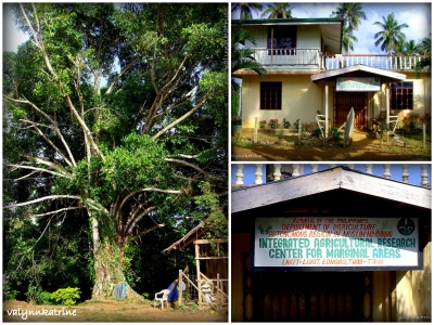
i took photos of the surrounding areas where ismael parked his tricycle. should some of you want to go to the balobok rock shelter, too, these photos will be of help to you: these landmarks will tell you that you already went past and, therefore, missed the turn for the boardwalk and the balobok arch!!! ^_^


a giant tree and the integrated agricultural research center for marginal areas
brgy. lakit-lakit, bongao, tawi-tawi


yes, we were in the right area but we actually stopped too far and missed the boardwalk and the natural rock arch by several hundred meters! haha. hahaha.

thanks to an act of hospitality, we experienced a great turnaround. a local going about his late afternoon activities took time to exchange pleasantries with us. when he learned that we were looking for the balobok rock shelter, he went out of his way to show us the path. we had to walk many, many, many steps back on the road! no wonder then why we initially did not see what we were looking for.


kat (left) walking with the kind local who showed us the way to the balobok rock shelter


the boardwalk and the balobok natural rock arch

the boardwalk which i got to know through the pictures shared in www.ironwulf.net was barely recognizable. a lot of planks were missing and some sections were in various stages of decay. it was sad to see that wooden walkway leading to the arch and to the rock shelter in such a state.


the boardwalk to the balobok rock shelter

despite the already really run-down appearance of the boardwalk, the balobok natural arch remained a mesmerizing sight to behold. it framed the cove fronting the rock shelter so perfectly. with parts of the boardwalk passing through it, there's a striking contrast that registered well in the several pictures that we took -- the robustness of nature's sculpture and the vulnerability of modern mankind's work.


the balobok natural rock arch

the balobok cove

beyond the massive circular rock arch and at the other end of the damaged wooden walkway, is the balobok rock shelter -- a shallow cave-like opening fronting the sea. it does not look impressive in the picture but it is, in fact, an important archeological site which, according to researchers, was "occupied during the mid-holocene (5000-8800 years before present), a period of neolithic (new stone age) culture expansion in the philippines."


the balobok rock shelter

the cultural and geological layers found at the balobok rock shelter are represented by the balobok column (or "haliging balobok"), which is displayed at the the national museum of the philippines. the column is a layered sculpture and looks like a short totem pole of hardened mushroom heads.


the balobok column 
national museum of the philippines

this is the english version of what is on the tablet:
"This column is a reconstruction of the cultural and geological layers uncovered in the excavations at Balabok Rockshelter in Tawi-tawi which dates to the Neolithic Period. Three cultural layers were identified by researchers, all of them being shell middens -- dumps filled primarily with shells. Each of the layers is slightly different in color. The artifacts and ecofacts found in the various layers were shells broken by human beings to extract the meat; bones of fishes and pig*, some of which indicate charring due to cooking; flaked stone tools; polished stone adzes; a bronze socketed adze; a red opaque glass bead; fragments of polished shell adzes and knives; earthenware pottery, and human teeth.  The shell and animal bone remains indicate the dual source of food available to the inhabitants of Balobok -- brackish water for shells and the forested land for a variety of animals."

*the Filipino version of the tablet states: "mga buto ng maliliit na mga hayop tulad ng ibon, paniki, baboy at usa" which translates to "bones of small animals like birds, bats, pigs, and deer."


there's definitely more to tawi-tawi than just being the philippines' last frontier in the south. tawi-tawi's balobok rock shelter is significant not only for the prehistory of the philippines but also of southeast asia. because of the neolithic period items found at the rock shelter, we know that tawi-tawi cradled the early inhabitants of the region and also preserved in her folds tangible records of their existence and cultural development. as early as thousands of years ago, there were already people who had this place as their vantage to view the rest of the world from.


up next: breathtaking tawi-tawi, truly breathtaking tawi-tawi


breathtaking tawi-tawi: our journey to the philippines' southernmost frontier | the series

Tuesday, July 30, 2013

from many angles: tawi-tawi's bud bongao


“Once you have traveled, the voyage never ends,
but is played out over and over again in the quietest chambers.
The mind can never break off from the journey.”
-- Pat Conroy

destination: bud bongao, the natural watchtower of the southern seas
this is part 6 of a series entitled breathtaking tawi-tawi: our journey to the philippines' southernmost frontier.


bud bongao location
and the starts & stops of our island hopping adventure in tawi-tawi

image source: google maps
(i provided the red and blue labels)


day 3. april 23, 2011. black saturday.
adventure 1: island hopping -- bongao, tango, panglima sugala, sangasiapu, laa, pababag, pasiagan
adventure 2: destination: bud bongao
adventure 3: destination: balobok rock shelter in brgy. lakit-lakit
adventure 4: destination: provincial capitol


a closer look at the google map: bud bongao and pasiagan


bud bongao (or bongao peak) is a prominent natural landmark in the southernmost province of the philippines. at 314 meters above sea levelit dominates the municipality of bongao and nearby areas with its flat top (read: table-like) appearance. people at sea or from neighboring islands can tell where the island of bongao is just by locating bud bongao in the horizon.


charming flat top | the table-like mountain of the south
bud bongao as seen from the pier in tubig indangan, simunul island
during sunset

because of its height relative to the rest of the landscape, bud bongao is also considered as a natural watchtower of the southern seas. at the top, the islands of sanga-sanga, sibutu, and simunul can be seen. more than that, sitangkai and even malaysian borneo are visible on clear occasions.


bud bongao, the natural watchtower

for the locals, bud bongao is more than just a landmark and a natural watchtower where foreign land (borneo) can be seen. for them, bud bongao is a sacred place where they go for pilgrimage and offer prayers.

during our 3-day tour in tawi-tawi, i had the privilege of seeing bud bongao from many angles -- from the national road as we crossed the bridge connecting the islands of sanga-sanga and bongao, from the governor's residence, from the middle of the sea as we were heading to sitangkai, from tubig indangan in simunul, from sangasiapu island, from the shores of pasiagan, and up close during our trek. from those different vantages, i took snapshots and clearly understood why it is unthinkable for bud bongao to be not part of one's tawi-tawi itinerary.

bud bongao and the landscape it defines
on bongao island and nearby sanga-sanga island:

photographed from mid-sea

bud bongao is difficult to miss -- this natural landmark is "everywhere" so much so that to be already there in bongao and not take the chance to experience it simply makes the journey incomplete.


seeing bud bongao "everywhere"
from top-left clockwise: bud bongao from beyond sangasiapu island,
bud bongao as part of the land transportation franchise sticker,
bud bongao as a t-shirt print design, and bud bongao from pababag island-side

on the day we arrived in tawi-tawi, bud bongao's towering presence and vegetated rocky slopes already made an impression on us. even when we went to the governor's place for a courtesy call, the mountain remained visible in the distance like a dedicated guard standing proud.


bud bongao watches over the governor's compound like a sentinel

bud bongao defines a very photogenic landscape in tawi-tawi's bongao island. whether from near or far, it is such a charming sight to gaze at.


bud bongao as seen from simunul's sangasiapu island

bud bongao, a closer look

on the shores of brgy. pasiagan, the mountain can be seen as an enchanting backdrop to a shrine simply adorned with white cloth.


bud bongao as seen from pasiagan

we were told by kuya jan and alvin that the shrine is actually a tomb of a revered virgin 'princess' -- a daughter of a royal family -- who lived and died centuries ago. the tomb of a revered male elder, also a member of a royal family, is one of the two graves near the summit of bud bongao. my impression is that, and if i understood correctly what kuya jan shared, this is how it is for the local pilgrims: "first, visit the daughter at the foot of the mountain, then go to the top to pay respects to the elder."


appreciating the mountain from afar and, eventually, up close
our bud bongao trek started where our island hopping adventure ended -- in pasiagan. after a day and a half of looking at the mountain from afar, we were finally at the foot and eager to conquer the peak.


kuya jan, alvin, and kat
my bud bongao climbing buddies

it was early afternoon when we started our trek and pasiagan was sun-drenched. the heat was draining our physical energies but, once we began our ascent, the vegetation of bud bongao gave us enough cover. the forested nature of the mountain allowed us sufficient respite from the sun as we followed the trail.


a coastal view of pasiagan
as seen from a few meters up the slopes of bud bongao

along the way, my attention was won over by some of the exposed rock layers that make up bud bongao. the patterns are interesting clues to how bud bongao was formed by the gentle might of the forces of nature.


bud bongao's rocky layers
  
the other things that got my attention were some abandoned pairless slippers, detached soles, and broken footwear -- it was easy to see that quite a lot already used the trail and not everyone had an easy time going to the top and back.

we had only gone up about one-fourth of the way to the summit when kat and i decided to retreat. awwww. the climb was not technically demanding and we already conquered higher peaks in other places but, on the slopes of bud bongao and after having been exposed to the sun too much during our island hopping adventure, we found ourselves already too exhausted to complete the climb.

we did not push any further and gave up thoughts of rewarding ourselves with views of tawi-tawi from the peak. we agreed to shift our excitement to seeing the balobok rock shelter, which was the next destination we listed on our tawi-tawi itinerary.


the long-tailed macaques of bud bongao

although kat and i failed to reach the summit, the long-tailed macaques of bud bongao still rewarded the time and effort we spent in visiting their protected mountain sanctuary. they showed up long enough for us to have a good look at them and to take their pictures. hooray, they did not drive us away! :)


up next: destination: balobok rock shelter and thereabouts


breathtaking tawi-tawi: our journey to the philippines' southernmost frontier | the series

Monday, April 22, 2013

the taraw adventure: cliff climbing in el nido, palawan


“Climb if you will, but remember that courage and strength are nought without prudence, and that a momentary negligence may destroy the happiness of a lifetime. Do nothing in haste; look well to each step; 
and from the beginning think what may be the end.” 
-- Edward Whymper


getting to know the taraw cliffs from afar

one rainy late afternoon in august 2009, my friends and i were walking around in el nido town when one of the locals talked us into climbing taraw -- the towering karst that dominates the town proper's coastal landscape.


more than just a backdrop
the taraw cliffs of el nido, palawan as seen from bacuit bay

we had just completed memorable days of island hopping in bacuit bay and, by walking around relaxed and unhurried, we were allowing things to wind down after all the exciting island adventures (and low pressure area-related misadventures, too) which we experienced in northern palawan. as we took in and enjoyed the rural vibe, along came kuya on the street telling us to pursue the taraw adventure.

at the mention of taraw, our attention shifted towards the intimidating cliffs -- massive and irregular walls of eroded limestone naturally defining one side of el nido town with sharp peaks, jagged rock faces, and vegetated high walls carved over ages by the sea, the winds, and other forces of nature. our initial reaction at the sight was, "really, it's safe for us to climb all the way to the top?"

under the gloomy sky that august afternoon, taraw looked like a part of mordor -- dark and ominous, impressive yet unfriendly. why climb it?


taraw as seen from el nido town

no cliff climbing adventure happened to any of us that time. the circumstances just weren't right. first, taraw was drenched by the rains and the rocky paths to the top were guaranteed slippery. why risk it? second, the day was about to end and darkness was about to set in. without daylight, climbing meant groping in the dark with nothing to see at the top but the flickering distant lights of the town. we also didn't have enough time to spare for the climb as our schedule was already full and we were soon leaving el nido for an additional one-day adventure in puerto princesa. why push it? most importantly, we just weren't ready then to take on the challenge of conquering the taraw cliffs. why dare the odds and flirt with too much trouble if you're not up for it?

BUT the desire to reach the peak of el nido's taraw took seed and grew in the backburner. the taraw adventure became part of the "one day, someday" to-do list.


the lure of taraw, the lure of the famous limestone cliffs on the eastern section of el nido poblacion

with good circumstances like sunny weather, great schedule, and adequate preparedness, taraw cliff climbing is an awesome adventure. it seems really risky and too physically demanding to scale the cliffs but reaching the peak is rewarding.


the awesome panorama as seen from the summit of taraw cliffs

there's the promise of seeing bacuit bay and more of el nido from an elevation of about 200 meters. the unobstructed breathtaking views -- bacuit bay, el nido poblacion, the coastline, and the lush forests of the northwest --  at the top make the climb more than worth it.

since 2009, i have been checking out online posts of people who dared and bravely stood at the top of taraw. i did my research on the cliffs this way and familiarized myself with the risks based on the online write-ups i've read and the taraw videos i've seen in youtube. i took inspiration from the informative posts and knew in my heart that, even though i am no seasoned climber, i, too, can conquer el nido's taraw someday.


destination: taraw peak

that someday happened to me last february, when i pursued a solo trip to palawan. having been to el nido before, the place felt so familiar and i was so at home and confident moving around in el nido town on my own. on the first day of my return in el nido, i joined a group tour to reach the hidden beach and the secret beach, two island hopping destinations which my friends and i didn't get to see during our adventures in 2009 due to unfavorable wave conditions.

towards the end of the island hopping tour, while our boat was docked on the shores of helicopter island and i was just sitting on white sand, i got the chance to share with our tour guide and our lifeguard-of-the-day my plan of pursuing the taraw cliff climbing adventure.


when in el nido, palawan, experience more than the usual

they're licensed guides for the cliff climbing activity, too, and they encouraged me to push through with my plan. i got their reassurance that climbing the taraw would not be as daunting as i first imagined it to be. with that, i was convinced not to pass up the opportunity. the first thing that i did, when our tour boat returned to the mainland, was to sign up for the taraw climb at the booking office of servant tours. the girl at the booking office took my name, checked my el nido ETDF (eco-tourism development fund) form-slash-ID, and assigned my guide for the following day. i was issued an official receipt for my climb fee -- PhP500, the standard rate in el nido for a solo guided climb.


23rd of february 2013
getting to know the taraw cliffs up close
a real deal rock climbing adventure in el nido, palawan

i set out early from my place of stay in el nido town. after informing my host that i was going to the cliffs that morning, i walked a short distance and, at 5:30am, i knocked at the booking office of servant tours. my guide, junjun concepcion, was already there. we agreed to meet early so i could start my taraw adventure at first light.

since it was still very dark when i showed up, junjun suggested that we wait for awhile before we head for the jump-off. although i came prepared and even had a headlamp in my light backpack, i understood the wisdom of postponing the start of the trek to the cliffs a wee bit so we won't have to walk in darkness. to while away the time, i went to the beach -- just some twenty steps away -- and took some pictures as the day's morning colors started to show.


anticipating daylight at the beachfront | el nido, palawan

cold sunrise | the panorama as seen from the beachfront in el nido, palawan

then, at 6am, it was time to get moving. junjun led the way and we entered a maze of alleys to reach the jump-off.

the jump-off is a natural pile of huge rocks at the foot of taraw and, in my opinion, the easiest part of the taraw cliff climbing challenge. once you get past it, expect to deal with more rocks -- bigger, sharper, and higher walls of rock -- as you make your way up, up, and up all the way to the top. right from the start, it is not an easy breezy kind of adventure. you have to be willing to use your hands, stretch your arms and legs, and be wise in choosing footholds as some rocks are unstable.


the journey to the top of the cliffs
following the invisible path to the summit

for safety reasons, climbing the taraw cliffs requires going with someone who knows his way up and down the cliffs. this is where climbing with a licensed guide comes into the picture. each licensed guide is only allowed to accompany a maximum of two guests per climb for a rate of PhP350 per person. for solo climbers, the guide fee is PhP500. the guide's knowledge of the path is crucial in helping you get to the peak of the taraw cliffs and in finding your way back to the town proper.

locating the jump-off point alone is a challenge in itself. one could easily get lost in the narrow community pathways and eventually miss the section of rocks where the trails to the top start. there are trails that the local guides established for the relative safety of their guests. a known trail, although you're likely not to see it on your own, is chosen based on whether one wants to go to the peak of the lower cliffs, which takes a shorter time to conquer, or to the summit of the higher peaks, which takes longer to reach but is more rewarding.


my guide, junjun, on the trail

where there are jagged rocks, more jagged rocks, and impressively high natural walls, there are actually established trails -- the "invisible paths" on taraw -- that the licensed local guides know by heart. reaching the top of the cliffs means befriending the rocks regardless of texture, shape, or size because, not only do they provide the handholds and the footholds, they are, collectively, the trail!

i aimed for the higher peaks of taraw and my guide, junjun, gamely led me to them.


taraw cliffs: lush vegetation and the high walls
oh, yes, part of the trail!

the trail to the summit was very irregular and the climb really required effort. there were only a few short portions of the trail where i was able to do normal walking. for the most part, i had to do scrambling and rock climbing -- never mind that i had no training nor much experience in either of the two, they're really essential to reach the top. avoiding the rocks, multi-storey high vertical walls, and pinnacles of the trail was not an option -- they're everywhere and, more importantly, although they undeniably represent RISKS in big bold letters, they're really the only way up.


looking at the world from the inner walls of the taraw karst
about one-half of the way to the top, i had this early morning view of bacuit bay

there were no ropes, harnesses, or other protective gear and falling was definitely not an option, too. i only had my hands, feet, strength, balance, common sense, and prayers. countless times, i really had to stretch my limbs to reach the next reliable handhold and to securely step on a stable foothold while pulling myself up the walls of rock. most of the handholds were really sharp and painful to grip but it's a good thing that i did not end up having cuts and scratches at all. it's a good thing, too, that i was comfortable with my tribu footwear -- i had no tripping nor slipping issues.

this adventure is not for the weak!


on the footbridge of pinnacles!

when we reached about three-fourths of the way up, we had to get to the other side of the cliffs via a most unlikely footbridge -- very high spiky rocks, irregularly-spaced pinnacles! in my opinion, this is the most difficult part of the trail. good balance is the key to avoid falling off the edges of these very high and very sharp rocks. my guide, who wore only thin-soled flip flops, casually walked on the tip of these rocks. i wanted to do the crossing like he did but my legs shook uncontrollably at the sight of the rocky skewers below so i crouched and crawled, hehe.

as we got closer to the summit and covered more altitude, the distances from foothold to foothold and between handholds became better. the pinnacles along the way were closely-spaced, too. while all these made climbing easier for me, the sheer height from the ground and the dangers of falling became more pronounced, making my knees feel wobbly involuntarily.


walking on a mountain cliff trail | sharp rocks everywhere

i noticed that some of the pinnacles close to the summit already have chipped edges -- the once very sharp tips must have broken off after several occasions of being stepped on or being gripped. seeing them made me realize then that i should even be more careful when putting some of my weight on the sharp edges of the rocks. i really had to stay sharp -- no pun intended, haha --- to plan my movements well. my thought was, "should these sharp sections give way so untimely, i could slip or lose my grip and, consequently, lose my balance."

the chipped edges made me realize one other thing, too: i was not surrounded by ordinary limestone! i was about 200 meters above sea level and i was traipsing on metamorphosed limestone -- marble!!! oh, marvelous!


experiencing the joy of being at the summit of the taraw cliffs
impressions of a self-confessed acrophobic

after an hour-long arduous climb with nothing to hold, step onto, and rest upon but piles of jagged rocks, crevices on vertical walls, and a footbridge of pinnacles, i finally reached the top of the taraw cliffs and was rewarded with a very stunning view of bacuit bay.


taraw cliff climbing? yes, great big check on my to-do list!

nobody else was at the top of the cliffs that morning. just as well. the summit offers unobstructed views of the great expanse below and beyond, effectively allowing one's sight to reach far and wide. however, in stark contrast to the seemingly limitless field that one's eyes can behold from that vantage is the very limited space where one can safely move around -- the top of the taraw cliffs cannot accommodate a lot of people. the summit is a lot like the trail -- very irregular and, because there is no flat surface to step on, the danger of losing good footing is very real.

and so it was great that i was able to have summit all to myself that sunny morning. sure, a guide was with me, but his presence didn't eat up the limited space and didn't take away the peace and quiet. with no one else moving about at that altitude, i felt solitude and that over-all relaxing atmosphere at the top of the taraw cliffs.

awesome! the sights to see from above really, really are!! the pictures do not even do justice to them.


basking in the rewarding joy of daring and cliff climbing!
below and beyond: the awesome view from the top of taraw cliffs :)

i stayed awhile just sitting close to the edge -- not the very edge! -- and allowed my senses to feast upon the sights: bacuit bay and the numerous boats, cadlao island, el nido town and the streets, the forested hills, and the white sand beaches. i stared with much appreciation at the wonderful world before me and, for a few moments, i actually forgot that i was acrophobic. haha.


jutting giant rocks and a peek at the world below the peak:
el nido town proper and bacuit bay


descending from the clifftop
getting to know the trail in reverse

because i dared to climb all the way to the top of el nido's taraw cliffs, i also had to take on the challenge of facing my fear of heights squarely, most especially when it was time to leave the clifftop. the trail going down is the same trail going up and, with pinnacles and vertical rock faces everywhere, the descent proved to be more daunting than the gruelling ascent since watching where i was going meant seeing how dangerously high i was from safe ground -- and, worse, there's no safe ground to fall onto the taraw trail.

with the help of my guide who assisted me in choosing what to grip and where to place my feet while scaling down the high walls, i did manage to get down safely.


the first level of rocks on the way up and the last level of rocks on the way down
yup, this is the jump-off point! :)

it took my guide and me an hour to reach the summit. it also took us an hour to descend all the way from the summit. in less than three hours -- with all that real deal climbing experience using only hands, feet, strength, and balance -- my guide and i were back in the town center.

what can i say? although they looked so sinister with their towering height and sharp facets, the rocks of taraw were so kind to me and did not give me injuries -- no cuts, no scratches, and no bruises; just some shaken nerves, haha.

what more can i say? it was a great morning made even greater by the fact that i made it safely to the summit and back. i dared to climb all the way to the top of el nido's taraw cliffs and the adventure did not disappoint. sure, both the ascent and the descent took a lot of effort but i was still able to enjoy and learn from the journey. i finally understood, too, what i first heard in 2009: go cliff climbing or your el nido adventure would not be complete without it. ,'-)


some useful postscripts

the taraw cliff climbing adventure is not for everyone. dare if you can but make sure you are well aware of your limits. the trail will require a lot more than what you normally give for the usual day hike or for a long walk in the park. be prepared to do free soloing -- rock climbing with no ropes! needless to say, this adventure is physically demanding.

it's not enough that you are an adrenaline junkie, your total being should be up for the challenge.


straight ahead: part the trail
no joke, you have to climb that wall (and that's not the only one!)

the easiest parts of the the taraw cliff climbing challenge? the start and the end... getting past the jump-off point, that is. why? because, there, the rocks are not too sharp, the angle of ascent/descent is not to steep, the risk of falling is not too much, and, in case of emergency, you are closer to getting more help. :D


leave your baggage behind. do not go to the cliffs with a heavy load. i mean that literally and figuratively: travel light and leave your troubles behind.

remember, you're going up the cliffs, where you would be pulling yourself up jagged rocks and vertical walls. bringing unnecessary stuff will not do good to your strength, balance, and over-all well-being. unnecessary load -- whether in your daypack or in your heart and mind -- will only significantly slow you down (if it doesn't do worse, like, actually bring you down).

wear what's appropriate for the activity and bring only what you need. keep your pack light and comfortable to carry.

in my case, my backpack had these: water, trail food, a pair of gloves (which i didn't use), headlamp, a small flashlight, insect repellant, cellphone, and first aid kit. the only "bulky" thing in my bag, aside from the bottles of water, was my dslr camera. i kept my point-and-shoot in the front pocket of my shorts.

remember to bring drinking water. it is essential.


establish camaraderie with your guide. of course, the pre-requisite to this is: go with a local guide, a licensed guide. do not go cliff climbing in el nido without one.


 at the summit | my guide, junjun concepcion

your guide is your necessary climb buddy. he will not only show you where the trails are, he will also help you get up or down the rocks safely. he will tell you to climb a multi-storey cliff face and you will think he's just kidding but he's not. he will assist you in choosing the handholds and the footholds appropriate for your built. his knowledge of the cliffs and the dangers will help you avoid falling into pits and dark cave-like openings, bumping your head against overhangs, stepping on unstable rocks, and tripping on wild vines. listening to his stories will keep you alert, making you more appreciative of your adventure.

at the summit, he will take your pictures. hehe.


respect the place, leave no trace. do not be like the others who went to the taraw cliffs before me and irresponsibly left their empty water bottles and food wrappers along the trail and at the summit. be a courteous guest of the cliffs. do not carve your name or leave any form of graffiti on the rocks of taraw. vandalizing the cliffs just so others will know that you've been there is not the way to build your legacy.


mind the rains, mind the sun. pray that it doesn't rain just before, during ascent, while you're there at the top, and during the descent. the mountain cliff trail is composed of rocks, rocks, and rocks, which are guaranteed slippery and difficult to deal with when wet. pray for just enough sunshine. doing the climb when the sun's already high up is not ideal -- your body will be needing more water for hydration, the rocks will be too hot to touch, and staying at the summit, where there is no shade, will be far from relaxing.


be careful. you do know that cliff climbing is risky, right?


Related Posts Plugin for WordPress, Blogger...