"a caterpillar doesn't just grow into a butterfly. a caterpillar must undergo metamorphosis, and a cocoon is where a caterpillar risks it all: enters total chaos, undergoes total rebuilding, and is born to a new way of living. only in taking the risk of entering that inert cocoon can the caterpillar go from dormancy to potency, from ugliness to beauty."

Saturday, September 15, 2012

walking around basey in samar


"An early morning walk is a blessing for the whole day."
--Henry David Thoreau


28th of august 2011
destination: basey, samar
"a quaint little town," according to one online resource
this is part 1 of a three-part series on basey, samar

we – yoni and i -- arrived early on a sunday morning in basey, samar. we included it as one of our stops during our 3-day leyte-samar tour because we were excited to see the caves and to experience our own sohoton natural bridge national park adventure. since we arrived early, we had time to walk around and learn more about the place first-hand with our own senses.

basey is one of the municipalities along the southwestern coast of samar in the eastern visayas region. it is a 30-to-45-minute trip by land from tacloban city with crossing the beautifully designed san juanico bridge as part of the roadtrip joys along the scenic countryside route.


where is basey, samar?
image source: google maps
(i provided the red label)

basey, despite the spelling and the supposedly implied ey sound for the ey vowel-consonant combination, is really pronounced as ba-sai as in ba-*sigh*.  the name originated from mabaysay or baysay, waray words for beautiful and beauty, respectively. the name is said to be in honor of bungansakit, a legendary beauty of the late 16th to early 17th century settlement in the area.  basey, while it is a deference to bungansakit, also represents the place, which was known then -- as it is known now -- for its natural beauty.

the 53, 272-hectare territory of basey covers coastal areas, inland plains, hills, mountains, & rivers and is home to fascinating caves, waterfalls, and extraordinary limestone formations. with its covered area, basey is the largest municipality in the province of samar. the geographic make-up of the place allows the population to engage mostly in agriculture and fishing for their livelihood.

basey is partially urban, mostly rural. the sunday morning local vibe that greeted yoni and me in the poblacion area of basey was warm and uncomplicated. people in the marketplace and those who were on the streets went about their morning activities in a hurried but still leisurely pace -- you know what i mean? let's just say that watching them was relaxing.

we walked along the roads of the poblacion and allowed our attention to be caught by the sights -- glimpses of countryside warmth and the serene basey municipal life. by the sidewalk, there was a modest-sized pig being roasted and two men watched over their lechon-in-progress. some pedicabs were on standby, their drivers waiting for passengers. like in other agricultural places, portions of the roads less traveled were utilized as driers for harvested palay grains.  a typical basey-tacloban-and-vice-versa van was parked and it probably wasn't scheduled for a trip that day.


walking around basey

the church of jesus christ of latter day saints in basey is the most unique church structure of mormons that i've ever seen. i'm used to seeing their churches all over the country and they always have wide lawns and basketball courts. their church in basey, however, is very different and could easily be mistaken for a very western-inspired modern-day residential building.


the church of jesus christ of latter day saints in basey

as we walked on, we passed by the signage for the local dating daan coordinating center there and got confused by the location -- it was on a corner and had curious surroundings.


ang dating daan coordinating center signage
which road to take? one roadside of that corner had cockfighting roosters
while the other roadside had a leashed pig :)

despite being already partially urban, basey has an undeniable old country feel. rightfully so. the place happens to be one of the oldest municipalities in the philippines. it was already recorded as a fluorishing settlement as early as 1591.

when you're in the poblacion area of basey and you happen to look up, the belltower of a very old church will most likely grab your attention. that structure is difficult to miss as it really dominates the area. the church sits on a top of a hill that overlooks san pedro bay. it's the st. michael the archangel parish, a coral church from the spanish colonial period. it is a distinct historical landmark of basey which has remnants of a fort as part of its surroundings on the hilltop.


the belltower of st. michael the archangel parish
a church from the spanish colonial period

yoni and i didn't miss our opportunity to examine the historical structure up close. we went up the stairs leading to the church and spent time looking around. it is a beautiful and interesting old structure, to say the least.


black and white | the st. michael the archangel church
a 17th century roman catholic church in basey, samar
the facade of the church masks its two-storey nature. the belfry
is located at the left wing of the church and provides a panoramic view of basey.

view of the belltower from the left-wing stairs
the bells are engraved with "basey" and date back to 1858

view of the old church's left entrance
as seen from the right entrance

interior of the st. michael the archangel parish | basey, samar

some old church details | st. michael the archangel parish

the national historical institute marker 
church of basey

the 1987 national historical institute marker for the church has this to say about it:
"a former parish of the jesuits under the diocese of cebu in 1591 and the dagami religious house in 1656. built with strong foundations by the jesuits in honor of st. michael the archangel. it was transferred to the care of the augustinians in 1768 and to the care of the franciscans in 1795 but assumption of their post and ministry did not happen until 1804. renovated and the belfry, stone convent, and walkway were constructed along with the cemetery and chapel by fr. domingo de madrid in 1845. destroyed by a typhoon in 1880. roofing was replaced with galvanized iron by fr. vicente gutierrez in 1894-1896. became a mission headquarters and center for doctrina christiana teachings. a fort during spanish period. meeting hall and where plays were staged during japanese occupation. evacuation camp during the liberation period."

just a short walk from the old church is the basey municipal tourism office, where arrangements can be conveniently made for the sohoton natural bridge national park adventure -- boatride, going to the caves, and the natural stone bridge tour included.


the basey municipal tourism office
open even on sundays :)

aside from being the stop of choice in the area for getting details on the caves and all the other attractions in samar, the basey municipal tourism office also has displays of basey mat products.

basey is not only known for wonderful caves and limestone formations, the place is also known for mat-weaving.

basey produced the world's longest mat in 2008. it was a two-something-kilometer long, one-meter wide mat made by the local weavers as part of their fiesta showcase. the guinness-worthy mat is no longer in the municipality because they donated it for the use of the ondoy victims in 2009.

weaving in basey is a way of life. it is a tradition that has been handed down from generations, even way before the coming of the spaniards. the mat or banig from basey are testaments to the discipline of the talented basaynons who industriously weave by hand thin pieces of dried sedge grass (Fimbristylis sp) locally known as tikog, which grow abundantly in the marshlands.


a basey mat product | a wall decor

a basey mat product | vintas

the resulting mat products are of good quality, very creatively designed, and often made bursting with vibrant colors so much so that their purpose goes beyond being sleeping mats. they are also used as materials for wall decors, bags, slippers, furniture matting, dividers, lampshades, etc.


Tuesday, September 11, 2012

getting to know the angono petroglyphs in binangonan


"History is a symphony of echoes heard and unheard.
It is a poem with events as verses."
--Charles Angoff


9th of june 2012
history, culture, and art appreciation day on a june 2012 saturday
a day for seeing the angono-binangonan petroglyphs (in binangonan, rizal) and visiting balaw balaw specialty restaurant and art gallery (in angono, rizal) among other things (like an afternoon drive and a nighttime drive through very slow moving traffic)


the angono-binangonan petroglyphs: the earliest pre-historic rock art in the philippines

many, many, many, many years ago (read: around 3000-2000 B.C.), somewhere in the elevated portion of what-eventually-got-referred-to (at some point, at least) as the common boundary of angono, binangonan, and antipolo of rizal province, human and animal-like figures were engraved on a wall of massive rock.  defined by an overhang and a shallow cave-like opening, the rock had volcanic origins and its surface was soft enough, chipping upon contact with tougher materials, but the wall as a whole remained resistant enough to preserve carved patterns with the passing of the ages.


the angono-binangonan petroglyphs: pre-historic rock art

for a long, long time, the existence of pre-historic rock engravings in rizal province, the cradle of philippine art, were not part of the public's attention. this changed in 1965 when carlos "botong" v. francisco, the renowned muralist from angono, rizal, reported to the national museum what he and a group of boy scouts discovered during a field trip  --  "a cave with drawings of a primitive quality."

the cave turned out to be a rock shelter and the drawings became known as the angono petroglyphs, with petroglyphs being the apt term for the 127 pre-historic carvings scattered on the 63-meter wide wall of ancient rock. in 1973, the site was declared as one of the philippines' national cultural treasures by virtue of presidential decree no. 260.


site of a natural cultural treasure | part of the 63-meter wide wall of the rock shelter

how to get there

according to the national museum's archeological sites and branch museums division (ASBMD) page for  the angono petroglyphs, "There are three two-hour routes from Manila to Rizal province. The northern route runs from Caloocan City to Marikina City. The middle route runs from EDSA to Pasig. The southern road passes through the town of Parañaque." 

for commuters, the blogspot of binangonan tourist attractions has this: "Take a metro bus, taxi or jeepney to EDSA/Crossing or the Farmer’s Market in Cubao, Quezon City and proceed to the jeepney or FX terminal within the shopping area. These vehicles are bound separately for Antipolo, Taytay, Cainta, Binangonan, Angono, and Tanay." once in binangonan, hire a trike... but... but... the roads going to the site of the petroglyphs are steep! check first with the driver if his trike can make it -- some can, most can't.

to get to the angono petroglyphs, our trio -- kat, bren, and i -- followed the directions shared by supernormalgirl. very, very useful! :)


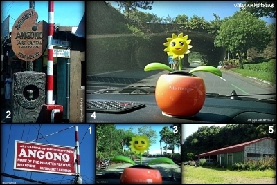
the landmarks we saw along the way which assured us that we were on the right track
(1) angono, art capital of the philippines and home of the higantes festival
(2) the angono marker in brgy. san isidro (3) just after the guard station along east ridge avenue
(4) the pretty tunnel leading to thunderbird resorts and casino, and
(5) the motorpool garage of the eastridge golf club

coming from the welcome tunnel of thunderbird and eastridge along east ridge avenue and col. guido road, there is an "angono-binangonan petroglyphs" marker on the left side. 


the marker along east ridge avenue-slash-col. guido road

just follow the direction of the yellow arrow leading to a dirt track. the motorpool garage of eastridge golf club is just nearby and the site of the petroglyphs is just a short walk away -- through a tunnel, around a bend, and along a straight path to the building of the binangonan branch of the national museum.


the oldest known work of art in the philippines and a national cultural treasure

the name "angono petroglyphs" is somewhat a misnomer. the rock shelter is located three and a half kilometers southeast of angono and it is already part of the municipality of binangonan of rizal province. since the name of the site already stuck and striking out "angono" from "angono petroglyphs" will only create confusion, present-day signages and references to the site use "angono-binangonan petroglyphs" and "angono petroglyphs in binangonan."


the marker

in order to reach the angono-binangonan petroglyphs, one needs to walk inside a 109-m long tunnel that cuts through a part of the hard, rocky mountain. this tunnel was constructed in 1996 and was finished in 1997 by expert igorot tunnelers/miners, who were especially commissioned by the national museum to make the process of making the dug out passage ecologically-friendly.


the tunnel leading to the angono-binangonan petroglyphs
(1) the entrance, (2) the exit, and (3)-(4) impressions on the ceiling of the 109-m long tunnel
they are marks of expertise of igorot miners who were commissioned to finish the tunnel in 1997.

inside the man-made tunnel

at the other end of the tunnel is a bend and further along the path is finally the welcome signage and the on-site museum, which was established by the national museum in 1998 to emphasize the cultural significance of the petroglyphs and to showcase the cultural and artistic heritage of the province of rizal.


the welcome marker: angono petroglyphs in binangonan

the binangonan building of the national museum: an on-site museum

the on-site museum is 240 meters away from the entrance of the tunnel. it houses a small exhibit and a collection of artifacts related to the petroglyphs and pre-colonial life. the building serves as the reception and registration area for the visitors of the petroglyphs, collectively regarded as the oldest known (and existing) work of art in the philippines.

the entrance/access fee to see the petroglyphs is 20 pesos per person but students get to pay only 50% -- 10 pesos each.


beyond that viewdeck, shaded by the canopies and lush greens,
is where the petroglyphs are
197 meters above sea level

the viewdeck is just a short uphill walk from the on-site museum.  it was constructed to keep visitors from touching the rock and degrading the existing ancient engravings. this was not the case before and there were some who actually thought it was cool to leave their own marks -- yup, not all engravings on the rock shelter are B.C. petroglyphs. some are contributions of modern-day vandals (read: mga pasaway!).


modern-day vandals' contribution :(

the petroglyphs and the rock shelter are also vulnerable to erosion and other natural occurring processes. in fact, the ground on which the rock shelter stands is showing tell-tale signs of shifting down and parts of the wall are riddled with holes. the holes are due to the roots of the trees that grew on the volcanic tuff.    


sharing space with the carvings on the ancient wall of rock are holes

according to the national museum, the site of the angono-binangonan petroglyphs is a highly significant cultural landmark and is listed in the world inventory of rock art. there is a collective effort by the national museum of the philippines, the world monument fund, american express, the department of tourism, and antipolo properties, inc. to preserve this national treasure which was recognized in 1996 as one of 100 most endangered sites in the world by the world monuments watch program of the world monuments fund.


getting to know the angono-binangonan petroglyphs
kat and bren with the on-site guide and information officer, mr. roden t. santiago

if you want to see the petroglyphs, know that the viewing days are mondays to sundays and the on-site guide & information officer's rest days are tuesdays and wednesdays. it is better to visit when he (mr. roden t. santiago) is around so you can interact with him and learn more about the petroglyphs. i suggest that you get in touch with him if you're planning to see the petroglyphs because he can provide you the many options and details on how to get there.

some online resources (read: blogs) say that DSLRs are not allowed at the site. let's correct that: DSLRs are allowed there. sir roden said so. plus, the management is open to allowing overnight camps in the area (i say, vandals and those who-don't-know-any-better are not allowed!) but just beware of the dahong palay snakes because the area has them.

should you take time to go and see the petroglyphs (why not, right?), take time also to visit balaw balaw specialty restaurant and art gallery and try their dishes in #16 don justo, doña justa village, angono, rizal.

we did!

what we ordered
balaw-balaw punch, ginisang balaw-balaw, ensaladang mangga, adobong baboy ramo, and tapang usa

balaw balaw specialty restaurant and art gallery
it's a restaurant and gallery in one!
remember, angono is the art capital of the philippines :)

balaw balaw, by the way, is a "delectable appetizer or sauce... made from small shrimps mixed with gruel and angkak, an herb that gives reddish coloring. the mixture is preserved in an earthern jar for three days."


Wednesday, September 05, 2012

once upon a nighttime photowalk in biñan city


"come on, ride the train 
it's the choo choo, ride it, woo woo
come on, ride the train, it's the choo choo train"
- c'mon 'n' ride it (the train), lyrics

it started with a train ride...
14th of august 2010
EDSA (makati city, magallanes near mrt magallanes station) 

"first time mo?" 

that's what i told myself as i approached the ticket booth. it was a fine saturday afternoon and i had just alighted the bus that took me from batangas to metro manila. i felt like a child going to school for the first time. one of my sweaty hands was holding on tightly to the strap of my tripod bag and my other arm was supporting my red backpack.

i was concealing the excitement that overpowered whatever apprehensions i had as i handed out my money in exchange for a ticket. for the regular commuter in the metro, maybe it was just another 10-peso ticket but, for me, it was special. it was the ticket for my first ever PNR commex train ride! hahaha!

the philippine national railways (PNR) is the state-owned railway company in the philippines, which operates a commuter rail service in manila and in the bicol area. if metrorail (lrt 1) is the yellow line, megatren (lrt 2) is the purple line, and metrostar express (mrt 3) is the blue line, the PNR commuter express (commex or cx) is the orange line, which provides passengers the train ride option along the route from tutuban and alabang.

my first ever PNR commex train ride was pleasant and comfortable. i was at the EDSA station and my destination that afternoon was 10 stations away, tutuban. eventhough i was on my own and eventually got myself surrounded by so many strangers as soon as i boarded the train, i did not find my solo adventure daunting. the commex service train's silver-colored hyundai rotem DMU coaches appealed to my senses. they looked brand new and safe and the airconditioning was working good -- something which was not lost on me especially during those stops when the coaches got heavily packed with passengers from all walks of life, it seemed.

when the train arrived at the station in tutuban, i got off. i stood for awhile on the platform and ended up gawking at the old train parked near the brand new-looking train i'd just left. the old train had blue coaches that looked decrepit but the sight of it got me excited. it was the reason why i made the trip to tutuban, after all.

seeing PNR's old blue commex train with my own two eyes was an assurance that, indeed, i arrived at the right station and somewhere inside the terminal building were people i knew who were waiting for me -- the members of the d60krew!  we were excited to feed our curiosity and to finally experience riding this relic of a train from tutuban to biñan.


from tutuban to biñan city

"This walk first started out as an orientation on the PNR COMMEX train that plies the Tutuban to Biñan route. We were already familiar with the new air conditioned trains that we rode during the WWPW PNR Leg, but the blue and gold COMMEX train is a relic that refuses to give in to time and age. Since the return trip to Manila was in the morning after, we thought it would be best to spend the night in Biñan shooting.” 

our group, the d60krew, gathered at the tutuban station which is just behind the tutuban mall in divisoria to catch the train ride that would take us to the city of biñan for a price of only 24 pesos per head.

while the PNR mainly uses airconditioned hyundai rotem DMU coaches for the regular commex service in metro manila,  an old non-airconditioned train is used for the once-a-day commex run between manila and  biñan city in laguna, around 2 hours and 15 station stops apart.

the train left the tutuban station according to schedule shortly after sundown. the ride was a totally different experience from the usual mrt and lrt rides. it was a totally different experience from its airconditioned PNR commex counterpart, too. while there was room to move and there were small counters between chairs that faced each other like in those trains in the movies, the chairs in the non-airconditioned coaches were not that comfortable. nevertheless, with the d60krew family, i got to enjoy the ride and was able to relish the experience of what it's like to be in an old, old train that still runs. yey!


inside the blue PNR commex train | the old train

during that ride, some of us were able to personally relate to the truth in this statement: "traveling on the old trains meant taking a chance as the coaches got thrown rocks or worse, plastic bags loaded with urine (or excrement)." it's safe to stay away from the windows and side doors when the train passes residential areas -- some urchins with nothing better to do might just be on standby on the railway side and throw something at the train. thank goodness for the grills that the PNR installed on the windows, we got initial protection from being hit with embers and broken pieces of hollow blocks -- no excrement. fortunately for passengers traveling on the new trains with airconditioned coaches and closed windows, they are shielded from crazy projectiles.

except for those moments when we got surprised by debris, most part of the trip was good and worth repeating. our group arrived in biñan safe and happy.


destination: biñan city, laguna

the city of biñan is about 34 kilometers south of manila and is a first class component city in the province of laguna. biñan used to be a municipality but she earned her cityhood in early 2010 by virtue of republic act 9740 and became the fourth city in the province of laguna after san pablo, calamba, and sta. rosa.

at the station in biñan, we were met by the municipal special action group (MSAG), a special arm of the office of the mayor of  biñan city. we were led to two vehicles and taken to mcdonald's at olivarez plaza for a dinner treat before our 9pm-to-4am photowalk. now, that i've shared those details, i need to emphasize something: a very impressive and humbling reception!

ate bambit of the d60krew wrote a letter to seek permission for our photowalk. the office of the mayor of the city of biñan responded graciously and gave our group permission to photograph their place at night. normally, a permit is just a piece of paper that could be shown to prove that an appropriate clearance was sought and approved. we got more than that. definitely, more than that.


the krew has landed. some of the d60krew members in mcdo | biñan

when we arrived in biñan, we were shown generosity and hospitality which were truly remarkable and beyond expectations. the MSAG was our security detail during our stay in biñan. the mcdo meals which we ordered got paid for thru arrangements made by ms. roseann gonzales, administrative aide of the office of biñan city mayor marlyn "lenlen" b. alonte-naguiat. during our overnight and sleepless stay in biñan, we were never left wondering where to go or how to access what nor did we end up worrying about our safety or the safety of our cameras as we walked around -- our escorts were very accommodating and responsible. the people we passed by and who passed us by were kind and friendly as well.

we really never expected all of that. it's wonderful how a simple act of courtesy such as sending a letter to seek permission begets an incredible show of hospitality. until now, i get to look back and really say, "that was very awesome!"


a vibrant biñan 

"The result: a more vibrant Biñan than anyone has ever seen, as caught by the lenses of the D60KREW ... and two Canons "

that night was not my first time to be in biñan. i've been to the place before but i never really stayed long enough, i merely passed by. that night, i had time -- time to observe, time to walk around, time to look at the old houses and the rise of the new establishments, time to see people as they went about, time to watch vehicle lights, time to take pictures, and time to allow the nighttime local vibe to sink in.

when the d60krew finally walked the streets of biñan in the poblacion area or the bayan, our first landmark stop was at the back of the house of maestro justiniano cruz. there is a rizal in biñan historical marker there because it was where jose rizal, the national hero, received his first formal schooling in 1871.


the rizal in biñan historical marker

i'd like to think that our escorts really made sure that we would never miss dr. jose rizal's first formal school -- it was the first landmark they led us to.


the d60krew taking their respective spots to shoot pictures of an old house across the street

we saw old houses and structures here and there -- attention-grabbing living memories of the old biñan that a young jose rizal also saw in his lifetime. it's a pity i wasn't able to get the family names of the owners of the houses -- except for the house of perlas and the alberto house, i could not identify which house is which in the pictures i took.

if you have the patience to read this account of the families of the old biñan and be acquainted with the street names, then perhaps, when you find yourselves in biñan, you will be able to identify the houses better than i could.


the old house across the street | this is the house in front of the 'rizal in biñan' historical marker
 the house of perlas: a decrepit bahay na bato from the spanish colonial period
the spanish era building beside jose rizal's first formal school
another old house that still stands

among the old houses in biñan, the most popular is, perhaps, the alberto house, a grand spanish colonial mansion, a bahay na bato with tile roof, built using materiales fuertes and strategically located in the old town center just in front of the present-day city plaza.


the alberto house of old  biñan is still the alberto house of present-day biñan 

estimated to be around 200 years old, it was the house of rizal's maternal grandfather, lorenzo alberto alonzo, and, therefore, his mother's ancestral home. the house is all the more historically significant because rizal lived there from 1870 to 1871 when his parents sent him to biñan for his first taste of formal education.


the alberto house as seen from the second floor of the old municipal hall

just near the alberto house and also facing the city plaza is the old municipal hall of biñan, which now serves as a police headquarters and a museum in the making. when we were there, there were photos and displays -- visual souvenirs -- of the rich history of biñan.


the century old municipio: the old municipal hall of biñan

along with the san isidro labrador parish church, the old municipal hall (also known as the century old municipio) stands on the west boundary of the city plaza.

next to the old municipal hall is the pamilihang bayan ng biñan, regarded as the largest public market in the province of laguna and in the CALABARZON region. we took the chance to shoot some pictures at the public market and saw with our own eyes how alive it is even at around 1, 2 o'clock in the morning.


pamilihang bayan ng biñan
the public market of  biñan
this vegetable vendor paid attention to my camera | public market of  biñan

our group's favorite subject that night was, without a doubt, the rizal monument at the city plaza and understandably so. the city plaza -- the jose rizal monument plaza -- is the major landmark of the city of biñan.

the jose rizal monument plaza in biñan city's poblacion as seen from the old municipal hall

the statue of rizal is located right at the center of the plaza, surrounded by the san isidro labrador parish church, the century old municipio, the multi-purpose covered court, and the alberto house.


long exposure shot no. 1 |  the jose rizal monument plaza of biñan
long exposure shot #2 |  the jose rizal monument plaza of biñan
a closer look of the rizal monument

the rizal monument in biñan is notable because it is one of the oldest monuments of jose rizal in laguna and also one of the very first rizal monuments in the country. when it was erected before the 1920s, the rizal monument in biñan was the second largest, next to the one in luneta. even with the unveiling last june 2011 of calamba's 22-foot statue of the national hero, which is now the largest rizal monument to date, the biñan monument remains as one of the largest monuments of rizal in the country.


the d60krew in  biñan! :)
check out our biñan thread in digital photographer philippines here:
 "The D60Krew Walks Binan at Night"

it was around 4 o'clock when i thanked the municipal security action group and the rest of the d60krew and took my leave. i was heading back to batangas while the rest of the d60krew were going to take the early morning (and only) biñan-tutuban train of the day to get back to their respective homes in manila. i boarded a south-bound jeepney with a very grateful heart for the wonderful experiences i had despite having to endure sleeplessness -- the PNR train rides and the overnight photowalk in biñan!

i know that i only walked and saw a small portion of biñan. there's more to biñan that you and i have yet to see.


Wednesday, August 15, 2012

In Focus: Iligan City, Her Lures, and More


"If I had fifty-three minutes to spend as I liked, 
I should walk at my leisure toward a spring of fresh water." 
-- Chapter 23 of The Little Prince, Antoine de Saint-Exupery


Every time I get asked where I am from, my quick reply is “Iligan City” --  the name of my birthplace, the name of my home. After I provide that information, the follow-up question I almost always get, if it's not a sheepish "Where's that?" from the geographically-challenged travel enthusiast, is this: “What’s in Iligan?”

Where is Iligan?
(image source: google maps)

Iligan City, a highly urbanized industrial city in the northern part of Mindanao, is approximately 795 kilometers southeast of the Philippine capital, Manila. 

Iligan's geographic location is strategically interesting in itself and puts her total territory of 81,337 hectares at the central part of the Visayas-Mindanao domestic economic growth area. The city defines her northern boundaries with the municipalities of  Lugait and Manticao of Misamis Oriental, her southern boundaries with the municipalities of Balo-i and Linamon of Lanao del Norte as well as the municipalities of Kapai and Tagoloan of Lanao del Sur. To her northeast is Cagayan de Oro City, to her east is the municipality of Talakag, Bukidnon, and to her west is Iligan Bay, which connects to the Visayas' Bohol Sea. These boundaries make Iligan the blessed crossroad of the diverse cultures of the Christian settlers & migrants, the Maranaos of Lanao del Sur, and the Higaonons of Bukidnon.

Iligan City in the Map of Northern Mindanao 
(image source: http://oftraveling.wordpress.com/2012/05/04/hello-world/)

Iligan City is not just my home. She is also home of the other 300,000+ Iliganons who identify with her rich cultural mix which, through the years, has allowed Christians, Muslims, and indigenous groups like the Higaonons to live harmoniously in one territory. Our Iligan is also home of Mindanao's major hydroelectric power source, various metal & steel-related industries, cement factories, and food processing mills -- all of which make her the country's Industrial Center of the South.   

Aside from being an industrial hub, Iligan is also blessed with natural waterscapes and is known as the City of Majestic Waterfalls. You see, one of the things that Iligan can really boast of is the abundance of water. On one side, she is bounded by lush mountains where cold springs and cascades of freshwater come from and, on the other side, she is bounded by a body of seawater. The city is blessed with more than 20 waterfalls and I will introduce you to four of them.

In Full Grandeur: The Maria Cristina Falls

Maria Cristina Falls, a stunning 98-meter high cascade of water, is the most popular among the many waterfalls of Iligan City. It is a major city landmark located in the Agus VI Complex of the National Power Corporation (NPC) found in the borders of Barangays Maria Cristina, Buru-un, and Ditucalan -- just about 9 kilometers southwest of the city proper.

Maria Cristina Falls perfectly represents both beauty and the veritable power of nature. At full grandeur, water flows generously from the top of a sheer cliff where a natural wall of jutting rock splits the water flow, creating a beautiful image of twin falls.

Maria Cristina's strong and voluminous water flow allows hydroelectric power generation by NPC's Agus VI Hydroelectric Plant, which utilizes 90% of the water of the Maria Cristina to generate power for Iligan and neighboring parts of Mindanao. The twin falls may not be visible all the time due to NPC's man-made controls on the water flow but Maria Cristina Falls remains photogenic and a mesmerizing symbol of nature's might.

The 98-m high Maria Cristina Falls under very controlled waterflow conditions. 

Maria Cristina Falls is best seen from the viewing deck at the third floor of the Agus VI Hydroelectric Power Plant during Sundays at 11 o'clock in the morning when waters are allowed to freely flow from the top of the drop to reveal the natural twin cascades.

Part of the pool several meters away from the foot of Maria Cristina Falls.
The booming sound of water and the a-swirling and a-foaming rapids at the foot of the drop should be enough to convince anyone that swimming in Maria Cristina's natural pool is not allowed.

Not very far from the jump-off to Maria Cristina Falls is Mimbalut Falls. It is located about 11 kilometers away from the city proper and is just a walking distance from the School of Fisheries in Brgy. Buru-un. 

Mimbalut Falls

Like Maria Cristina, Mimbalut Falls is also visually striking. In contrast to Maria Cristina, Mimbalut Falls is not so high at only 27 meters from the top of the drop to the bottom. The beauty of the falls is in the way the water creates an approximately 5-meter wide curtain as it cascades along rocky slopes. The sight is very soothing. The water flows gentle enough for one to enjoy getting wet and taking a dip.

Well-hidden 13.8 kilometers away from the city proper and also accessible via Brgy. Buru-un and existing truly to its name is Tinago Falls, a captivating well-known scenic spot in Iligan City.

Tinago (translation: hidden) is so named because of its location and accessibility. It is hidden deep in a ravine and, to see the cascading waters, one has to go a long, long way down first -- like 350+ steps. This means that anyone who wishes to see Tinago must be physically fit to make the energy-zapping trip to and back from the falls. The wonderful sight of Tinago's cascading waters and the 55-foot deep turquoise lagoon is a lure worth pursuing and "toiling" for.


Tinago Falls
Ain't Tinago a marvelous sight? Cool, clean and clear water, as freshwater should be! It's fun to swim to the foot of the 73-m high falls and meet the waterdrops there. Actually, they're more like jets of water beating down on your head and body -- free natural massage with cool ouch factor! 

Located some 14.5 kilometers north of the city proper, between Barangays Bonbonon and Digkilaan, is a 20-meter high picturesque waterfalls called Dodiongan. Getting to the waterfalls involves riding a habal-habal (motorcycle) from Brgy. Barina-ut to get to the jump-off and a trek along uneven paths and rocky trails surrounded by very countryside scenery.

Dodiongan Falls

Dodiongan Falls is an interesting sight to behold. The volume of water splits into two at the start of the drop and each section slides along concrete-like boulders. The water on the left section cascades more gently like a fast moving veil, while water on the right section falls down more strongly like an angry rush of water. The plunge pool of clear, cold water is good for swimming.

For those who do not want to go trekking but still want to enjoy swimming in water that's flowing, icy cold, and crystal clear, Iligan City has an array of resorts with free-flowing freshwater pools in Timoga, Brgy. Buru-un. 


Enjoy water that's free flowing, icy cold, non-chlorinated, and crystal clear!

Visit Iligan, explore and experience the place to satisfy your curiosity and your longing!

This is an official entry to the Iligan Blogging Contest 2012.


Related Posts Plugin for WordPress, Blogger...